Last update
2025
Summary
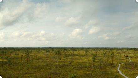
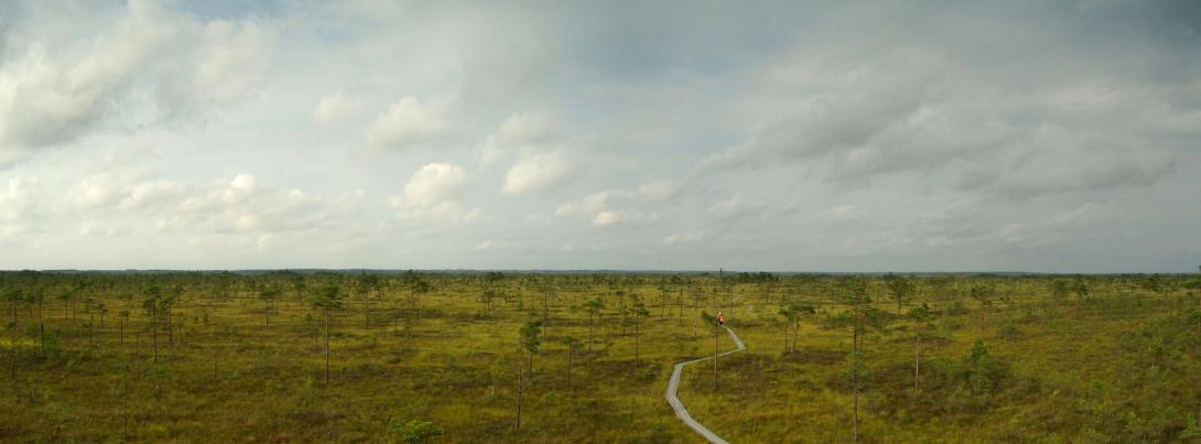
The restoration of the Kuresoo bog aimed to re-establish the natural water regime and typical bog vegetation in a severely drained area within Soomaa National Park, Estonia. Restoration was implemented on a pilot area of approximately 60 ha, where ditches were blocked with peat dams, brushwood and plastic piling. The area had been drained in the 1950s for peat extraction and forestry, resulting in significant degradation of the bog ecosystem.
Monitoring indicates that water levels have been successfully raised, resulting in the development of typical bog vegetation such as sparse pine cover and Sphagnum moss. These changes help reduce carbon emissions from the formerly degraded peat soil and support biodiversity conservation.
Recent sources confirm that over 1,000 dams were built across ~3,000 ha of degraded peatlands at Kuresoo as part of broader national efforts under the LIFE Mires Estonia project (2015–2021). Restoration planning employed drone-based LiDAR surveys and hydrological modelling, while fieldwork included local volunteers and national institutions. Long-term monitoring confirms a stable rise in water levels, recovery of bog vegetation, and return of protected bird species. Some initial restoration structures required corrective work to improve hydrological effectiveness.
As of 2023, the Kuresoo bog restoration is recognized as a national best practice example and has contributed significantly to Estonia’s peatland restoration targets, particularly within Natura 2000 habitats. The site continues to be managed by RMK, with ecological monitoring by the University of Tartu and ELF.
Position
Latitude
58.4847
Longitude
25.1363
Project
NWRM
National Id
Estonia_02
Installation date
2013-02
Implementation Status
Contact
Sandra Oisalu, BEF Estonia
RBD code
EE1
Transboundary
0
Photo gallery
Location of the project
The Kuresoo bog is located in central-western Estonia, within Soomaa National Park, in Viljandi County. It lies in a remote, lowland forested area characterized by extensive wetlands and peatlands, forming part of one of the largest intact bog complexes in the country.
NUTS Code
EE00 - Eesti
Involved Partners
| Authority type | Authority name | Role | Comments |
|---|---|---|---|
Climate zone
cool temperate moist
Temperature
5 °C
Annual rainfall range
300 - 600 mm
Elevation range
27
Slope range
0-1%
Vegetation class
Pleurozium schreberi, bog blueberry, Ledum palustre, S. angustifolium, S. magellanicum, S. fuscum, S, rubellum, pine
Water bodies: Ecological Status
Moderate
Water bodies: Chemical Status
Good
Project scale
Meso
Project scale specification
The project covers an entire bog.
Project area
80
Area subject to Land use change or Management/Practice change (ha)
80
Design capacity description
the overflows of the barrier dams bring down the water level either 20 or 25 cm each. There were built 29 wooden dams (5 different types to test applicability of different types) and 28 peat dykes
Total cost
161900
Costs total information
Does not include the background studies - only construction works : construction of barrier dams and dykes and surveillance.
Application for practical work was financed by European Regional Development Fund. The background searches and restoration plan was made in frame of INTERREG IIIA programme.
Application for practical work was financed by European Regional Development Fund. The background searches and restoration plan was made in frame of INTERREG IIIA programme.
Costs operation maintenance information
No maintenance needed, one time activity
Financing authorities
Type of funding
EU-funds: Cohesion and regional development funds
Comments
Via Estonian Environemntal Investment Centre
Type of funding
National funds
Comments
INTERREG IIIA programme : background searches and restoration plan.
Type of funding
National funds
Comments
INTERREG IIIA programme : background searches and restoration plan.
Type of funding
National funds
Comments
INTERREG IIIA programme : background searches and restoration plan.
Type of funding
Private funds
Comments
INTERREG IIIA programme : background searches and restoration plan.
Policy context
Kuresoo bog is one of the largest and well conserved consistent bog complexes in Europe (main habitat types 7110*, 91D0*) with total area 11 000 ha. In the south-east part there is 80 ha area we forest drainage system was built in 1970s. Drained area impacts directly ca 300 ha bog area nad the drained area as been designated as 7120 area (restoration is possible). Restoration of the drained area water regime will help to reduce its impact to the main bog. Since 2009 Soomaa national park belongs to PAN Parks network and Kuresoo bog is its core area. Kuresoo bog has salso been noted as internationally important bird area (IBA - International Bird Area), internationally ipportant wetland (RAMSAR) and it is also part of Natura2000 network.
Land ownership
State-owned land
Community involvment
Yes
Design consultation activity
| Activity stage | Name | Key issues | Comments |
|---|---|---|---|
|
Implementation phase
|
Volunteering
|
Local volunteers were involved in dam building and outreach activities, fostering public support and awareness of peatland values.
|
Policy target
| Target purpose |
|---|
|
Improved Biodiversity
|
Policy pressure
| Pressure directive | Relevant pressure |
|---|
Policy impact
| Impact directive | Relevant impact |
|---|
Requirement directive
| Requirement directive | Specification |
|---|
Contractual arrangements
0
| Arrangement type | Responsibility | Role | Name | Comments |
|---|
Part of wider plan
0
Wider plan type
| Wider plan type | Wider plan focus | Name | Comments |
|---|
Hydrological monitoring - piesometric levels, ground pH and electrical conductivity, chemical copmposition of ground andand water od ditches, hydraulic conductivity of peat.
Vegetation cover(1,2,4,6 and 10th year). Topographic surveying after 10 years.
Vegetation cover(1,2,4,6 and 10th year). Topographic surveying after 10 years.
Catchment outlet
Monitoring will show if the priority habitat types (7110* and 91D0*) have improved
Information on Maintenance baseflow
Ditch blocking: Over 1,000 dams (peat, wood, plastic) blocked historical drainage networks, restoring natural water flow and retention.
Information on Increased groundwater level
Raised water table: Restoration successfully raised and stabilized groundwater levels across the siteIn some restored zones, the water table rose by 30–50 cm during wet seasons
Information on Restoring hydraulic connections
Wetland area expanded: Rewetting reconnected isolated patches into a more continuous mire system over ~3,000 ha.
Information on Increased landscape storage capacity
Seasonal water retention: Enhanced capacity to buffer seasonal rainfall and flooding within Soomaa's “fifth season” (spring floods).
Water quality overall improvements
Not relevant for this application
Information on Water quality overall improvements
Water quality is in good status. Problems were with hydrological regime.
1
Bog vegetation recovery: Recolonisation by Sphagnum mosses, sedges, and scattered Pinus sylvestris (Scots pine) observed across restored plots.
Notably, golden plover (Pluvialis apricaria) and wood sandpiper (Tringa glareola), both EU-protected, have been observed breeding again at the site.
Habitat restoration: Enhanced connectivity of habitat for mire-specific fauna and flora, contributing to the favourable conservation status of EU habitat type “active raised bogs”.
Rehydration of peat: Moisture levels in the upper peat layers increased, reducing peat decomposition and oxidation.
Reduced subsidence: Restoring waterlogged conditions limited further peat shrinkage and subsidence in formerly drained sections.
Reduced subsidence: Restoring waterlogged conditions limited further peat shrinkage and subsidence in formerly drained sections.
Ecosystem impact climate regulation
Impact on GHGs (net emissions and storage) including soil carbon
Information on Ecosystem impact climate regulation
Reduction of CO2 emissions and
Information on Ecosystem impact GHG soil carbon
Restoration thus contributes to carbon sequestration in the long term by restoring Sphagnum growth.
Key lessons
Kuresoo will be definitely bog restoration example area in Estonia where it will be possible to assess the impact of hydrological regime restoration to Sphagnum mossgroth and effectiveness of different damming technologies. Even though there were studies made for the area and restoration then in practice it turned out that additionally to wooden dams also peat dykes were built as wooden dams did not rise the water lever equally.
Large-scale restoration is feasible with proper planning and coordination
High-resolution planning tools improve restoration design
Restoration effectiveness varies and may require adaptive management.
Monitoring and post-project adjustments were crucial for long-term success.
Public engagement adds value.
Success factor(s)
| Success factor type | Success factor role | Comments | Order |
|---|---|---|---|
|
Financing possibilities
|
1
|
||
|
Available support tools
|
main factor
|
The use of LiDAR drone imagery and 3D hydrological modelling before implementation allowed precise identification of drainage impacts and optimal locations for ditch blocking. |
2
|
|
Successful coordination between authorities
|
main factor
|
Success was enabled by strong collaboration between state actors (RMK), NGOs (ELF), researchers (University of Tartu), and EU funding (LIFE). |
Driver
| Driver type | Driver role | Comments | Order |
|---|
Flexibility adaptability
Some early restoration structures (dams) were found to be hydrologically insufficient and had to be corrected or reinforced later.
English