Last update
2025
Summary
Between 1990 and 2005, the River Quaggy programme in southeast London combined river restoration and flood management to address growing urban flood risk: de-culverting and reconnecting floodplain (notably at Sutcliffe Park), construction of detention basins, set-back defences and channel re-profiling. The scheme took a catchment-scale view, was delivered by a multi-disciplinary team, and drew heavily on community advocacy. Since then, the sites have been managed as long-term green infrastructure: Sutcliffe Park is a Local Nature Reserve with a 2019–24 management plan (updated 2022) to maintain flood-storage function and biodiversity. Lewisham’s 2022–27 Local Flood Risk Management Strategy adopts a “make space for water” approach and cites Quaggy/Sutcliffe Park as exemplars. Recent works extend benefits upstream at Chinbrook Meadows, where Thames21 and partners created new wetland cells (2023–24) to intercept the polluted Grove Park Ditch, improve water quality and habitat, slow flows and enhance community amenity; the wetlands opened to the public in September 2024. River status has also evolved: the Environment Agency now classifies the Quaggy water body as having Moderate ecological status (2025), with physical modification and point-source pollution remaining pressures.
Position
Latitude
51.455042
Longitude
0.030134
Project
NWRM
National Id
United Kingdom_02
Installation date
1990-2005
Implementation Status
Contact
Heather Williams and Katie Hill, AMEC
RBD code
UK06
Water body code
GB106039023290
Transboundary
0
Photo gallery
Location of the project
The case study is located in south eastern part of the United Kingdom, in south east London. A heavily urbanised area, at an altitude of approximately 70m AOD.
NUTS Code
UKI1 - Inner London
Project's objectives
Provide ~1-in-70 protection and reduce flood risk for ~600 properties, restore connectivity and habitat, and create high-quality public space; deliver ~150,000 m³ combined upstream storage; restore up to ~4 km of channel/river corridor.
Involved Partners
| Authority type | Authority name | Role | Comments |
|---|---|---|---|
Climate zone
cool temperate moist
Temperature
11.9 °C
Annual rainfall range
600 - 900 mm
Runoff range
150 - 300 mm
Imperviousness range
40 - 60%
Remarks runoff imperviousness
Based on estimate of the Urban extent across the catchment.
Elevation range
18 m
Slope range
2-5%
Vegetation class
Mosaic of wetlands/reedbeds, damp grassland, ponds/lake with riparian scrub and native trees following de-culverting and floodplain reconnection.
Water bodies: Ecological Status
Moderate
Water bodies: Chemical Status
Unknown
Water quality status
Key pressures: sewer misconnections, intermittent sewage discharges/overflows, urban/transport runoff, and physical modification/barriers; phosphate poor; specific pollutants incl. PBDEs, metals, triclosan.
Project scale
Meso
Project scale specification
Multi-site scheme along a sub-catchment/river reach (~4 km) with two upstream flood-storage areas and reach restorations; conceived at catchment scale to lower downstream flood peaks.
Performance timescale
Immediate
Project area
1750
Area specifications
This is the catchment area of the River Quaggy upstream of its confluence with Ravensbourne River. The NWRMs are upstream of this point so the overall area that is treated by the NWRMs is slightly less.
Area subject to Land use change or Management/Practice change (ha)
7
Size
4300
Size unit
m
Lifespan
Overall expected to be 50+ years with occasional maintenance
The primary principle was to ensure effectiveness in managing downstream flooding. As part of this aesthetic benefit was a key requirement to ensure no loss of the green areas already limited within the urban environment. In order to enable this, it was also important to have landowner acceptability and involvement.
Weigall Road:The overall design aim was to achieve a 1 in 70 year level of flood protection
Design capacity description
The overall River Quaggy Scheme provides flood protection for a minimum of a 1 in 70 year event.
- Sutcliffe park floodplain has capacity for 85,000m3 of flood water
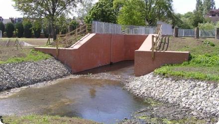
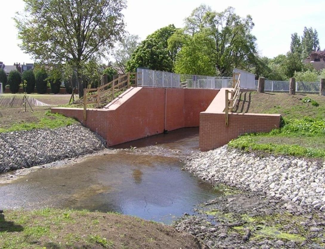
- Weigall Road detention basin has capacity for 65,000m3 of floodwater, and the inflow maximum is designed for a 1 in 70 year flood event, with maximum inflow of 5m3/s through the flume.
- Sutcliffe park floodplain has capacity for 85,000m3 of flood water
- Weigall Road detention basin has capacity for 65,000m3 of floodwater, and the inflow maximum is designed for a 1 in 70 year flood event, with maximum inflow of 5m3/s through the flume.
Downstream of Manor Park, flood defences were once concrete walls, with plans to raise them—threatening mature trees. Strong opposition led to set-back defences built into private gardens instead. Locals and politicians pushed for upstream flood storage to protect trees, but councils feared flooding parks would reduce their amenity value. Surveys later showed benefits to amenity. At Sutcliffe Park, where the river was culverted, new flood storage solutions were needed. A catchment-scale approach enabled upstream storage, reducing downstream risk and allowing more flexible in-channel measures.
These NWRMs are suitable to be used within any urban environment, however will be limited to sites where suitable green areas are available (although some measures can be very flexibly incorporated, for example within gardens). Re-meandering a channel and creation of a detention basin are constrained by the avaialbility of land of a size suitable.
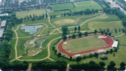
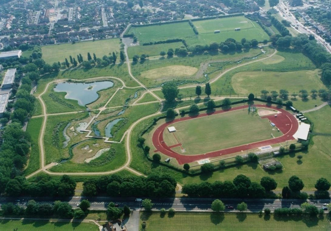
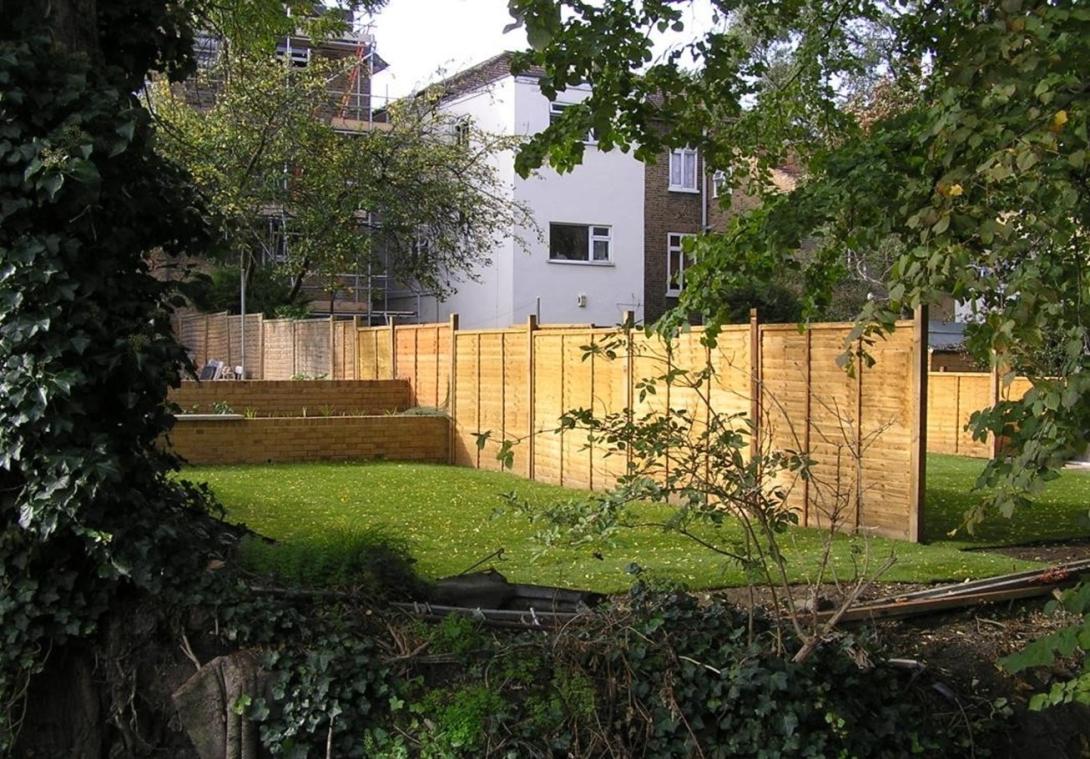
Sutcliffe Park: the existing watercourse was culverted underground, and provided the ideal oportunity for flood risk management that would combine with river restoration, with existing recreational ground providing a suitable environment.
The urbanised nature of the Quaggy catchment and the direct implications to residential properties and local amenities results in a community that was ready to be involved.
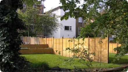
The channels at the back of residents houses downstream of Manor Park are heavily tree lined, and so previous approach of raising the concrete channel wall was deemed unsuitable due to the resultant loss of the trees. A alternative was required,with political desire for storage rather than tree loss, and therefore set back defences were used instead.
The urbanised nature of the Quaggy catchment and the direct implications to residential properties and local amenities results in a community that was ready to be involved.
The channels at the back of residents houses downstream of Manor Park are heavily tree lined, and so previous approach of raising the concrete channel wall was deemed unsuitable due to the resultant loss of the trees. A alternative was required,with political desire for storage rather than tree loss, and therefore set back defences were used instead.
Positive influence effectiveness
Green spaces like Sutcliffe Park and gardens near Manor Park enabled effective flood measures, such as daylighting the channel and set-back defences, to work well within the urbanised catchment.
Negative influence effectiveness
None identified
Total cost
€ 14.7 million
Costs investment
€14,700,000
Costs investment information
This excludes consultancy fees.
Total approximately €14,700,000
Sutcliffe Park and John Roan School site: €4,700,000 to construct
Weigall Road and Eltham Palace Road: €2,600,000 to construct
Downstream of Maor park flood defences: €7,200,000
Total approximately €14,700,000
Sutcliffe Park and John Roan School site: €4,700,000 to construct
Weigall Road and Eltham Palace Road: €2,600,000 to construct
Downstream of Maor park flood defences: €7,200,000
Costs operational information
Operation is required of sluices during flood conditions.
During flood events park gates to be locked and to remain locked whilst park is flooded, and warning notices to be posted at park entrances to advise the public why the park is closed.
As flood waters subside, litter picking is required of the entire flood storage area and clearing of excess debris from habitat areas and structures and clearing excess silt from all areas is required. These are all required to ensure full effective operation of the scheme during subsequent flood events. No information is provided on costs associated with this.
Costs operation maintenance information
There are operational and maintenance costs accociated with the scheme
Costs maintenance information
Maintenance is now undertaken by the associated Borough of the Park. For example London Borough of Greenwich for the Sutcliffe site.
Sutcliffe Park: flow control structures within the park have been designed to be maintenance free but channel widths and depths are to be maintained, with 1 visit every 10 years and Annual inspections of vegetation within channels. Similar long term managment approaches are used for the grasslands, wetlands and lake within Sutcliffe park.
Sutcliffe Park: flow control structures within the park have been designed to be maintenance free but channel widths and depths are to be maintained, with 1 visit every 10 years and Annual inspections of vegetation within channels. Similar long term managment approaches are used for the grasslands, wetlands and lake within Sutcliffe park.
Costs disposal decommissioning information
No information provided
Financing authorities
Type of funding
National funds
Type of funding
Local funds
Comments
Whilst the majority of works were financed by the Environment Agency, some of the river restoration works were funded through local partnership funding
Compensations
0
Compensations annual information
No known payments made.
Compensations nr beneficiaries information
There were no financial benificaries
Policy context
As urban development in the River Quaggy river valley and natural flood plain, near Lewisham in central London, is increasing, fluvial flooding experienced by local residents and businesses has increased. In 1968 the centre of Lewisham flooded to a depth in excess of 1m, and more recent flood events have occurred. A flood alleviation scheme was required that would ensure minimal loss of the remaining floodplain within the catchment.
Land ownership
Public land: Sutcliffe Park & Weigall Road Sports Ground owned/managed by Royal Borough of Greenwich; Chinbrook Meadows owned by London Borough of Lewisham.
Community involvment
Yes
Design consultation activity
| Activity stage | Name | Key issues | Comments |
|---|---|---|---|
|
Design phase
|
Before construction meeting and stakeholder involvement
|
In the case of the area downstream of Manor Park residents were involved in the designing of the defences put in place in their gardens
|
|
|
Implementation phase
|
During construction meeting and stakeholder involvement
|
||
|
Implementation phase
|
Progress meeting to say how its developing
|
||
|
Other
|
Getting people involve in the 'soft' works
|
Schools, community groups etc were involved in soft works - e.g. Bird boxes.
|
Policy target
| Target purpose |
|---|
|
Increase Water Storage
|
|
Peak-flow reduction
|
|
Oher Societal Benefits
|
|
Improved Biodiversity
|
Target Remarks
Flood control and flood risk mitigation, Regulation of hydrological cycle and water flow. The scheme reduces flood risk to 600 homes and businesses.
Policy pressure
| Pressure directive | Relevant pressure |
|---|---|
|
Other non-EU
|
Natural Exceedence - Flooding of land by waters exceeding the capacity of their carrying channel or the level of adjacent lands
|
|
Other non-EU
|
Physical alteration of channel/bed/riparian area/shore of water body for flood protection.
|
|
Diffuse - Urban runoff - Storm overflows and discharges in urbanized areas not identified as point source
|
Pressures remarks
The flood alleviation scheme was implemented between 1990 and 2005, prior to WFD and FD, but subsequent comparison shows compliance with and benefits to a number of the Directives.
Policy impact
| Impact directive | Relevant impact |
|---|---|
|
Other non-EU
|
Property - Adverse consequences to property and businesses.
|
Impact remarks
The flood alleviation scheme was implemented between 1990 and 2005, prior to WFD and FD, but subsequent comparison shows compliance with or support for those directives.
Requirement directive
| Requirement directive | Specification |
|---|---|
|
Floods Directive-mitigating Flood Risk
|
Address risk of flooding to local and downstream properties
|
|
WFD-mitigation of significant pressure
|
De-culverting
|
Requirement directive remarks
As noted above, the WFD and FD were not in place at the time of implementation. Nevertheless the measures directly contribute to the FD and WFD objectives.
Policy challenges requirements
The WFD and FD were not in place at the time of implementation, but comparison has subsequently been made with these and a number of local policies for which the scheme is complaint. A number of these policies include:
- London Green Infrastructure Policy
- Thames catchment flood management Plan
- London Green Infrastructure blue ribbon network Policy - London Borough of Lewisham River Policy.
- London Green Infrastructure Policy
- Thames catchment flood management Plan
- London Green Infrastructure blue ribbon network Policy - London Borough of Lewisham River Policy.
Contractual arrangements
0
| Arrangement type | Responsibility | Role | Name | Comments |
|---|
Part of wider plan
0
Wider plan type
| Wider plan type | Wider plan focus | Name | Comments |
|---|---|---|---|
|
Local
|
Environment & Biodiversity
|
Greenwich’s Sutcliffe Park Management Plan
|
Biodiversity, recreation, water
|
|
Regional
|
Water
|
Thames Catchment Flood Management Plan
|
Flood risk management
|
The Sutcliffe Park Management Plan (2019-2024) outlines ongoing ecological monitoring and maintenance.
A number of parameters were monitored during different stages of the scheme.
Prior to construction, eleven baseline surveys were carried out including surveys of riverine flora, trees, bats, fish, invertebrates, birds and mammals to inform designs in progress and enable the process of environmental impact assessment.
Water Quality and Sediment sampling was also undertaken during the work.
Socio economic surveys have been undertaken since the completion of the scheme to monitor visitor numbers to the site follwoing the NWRM implementation. Other Social, economic and heath studies have been undertaken.
An existing monitoring point, located at Manor Park, was used between 1993-1995.
The scheme was implemented pre-WFD, but for maintenance monitoring , standard monitoring points associated with the WFD are now used.
The scheme was implemented pre-WFD, but for maintenance monitoring , standard monitoring points associated with the WFD are now used.
Up until 1994 there was a Water Quality monitoring site at the bottom of the Quaggy at Lewisham High Street.
The scheme was implemented pre-WFD, but for maintenance monitoring , standard monitoring points associated with the WFD are now used.
The scheme was implemented pre-WFD, but for maintenance monitoring , standard monitoring points associated with the WFD are now used.
Maintenance
Sutcliffe : Flow control structures are designed as maintenance free. Annual inspections of vegetation within channels. During floods, park gates are locked & warning notices posted at the entrances. Clearing excess silt and debris after flood.
Laboratory
The method included before-and-after studies, expert evaluations, and public feedback. The Environment Agency and QWAG used ecological surveys, flood modelling, and community perception surveys to assess impacts.
Biophysical impacts were assessed using hydrological models, biodiversity counts, and habitat quality surveys. Cost assessment included capital expenditure breakdowns and comparisons with traditional flood defenses (see EA Factsheet, 2008).
A Health Study was undertaken in 2005 on the increased usage of Sutcliffe Park.
A Economic study was undertaken in 2005 on the benefits of the works at Sutcliffe Park, and considers other housing proposals in the area.
An MSc was undertaken in 2004 looking at the methods of public participation in the restoration of Sutcliffe Park - Bringing the river to life? Myths, motivations and practicalities of community involvement in urban river restoration.
The use of a network of NWRMs in a predominantly urban landscape provides a cost effective and adaptable means to reduce flood risk, while providing amenity value to highly populated area.
Additional benefits include:
- Creating meandering river and detention basin provides new habitat for wildlife.
- The increased habitat and biodiversity in the catchment, which is also indicative of improved water quality.
- 73% increase in the number of visitors to Sutcliffe Park, and visitors generally stay longer than previously
Sutcliffe Park: Throughout the project there has been a Community Liaison Officer, employed by the Environment Agency, to link with the local people and particularly the local schools, youth groups and residents' groups. There are many opportunities within the park for community projects, during implimentation and following. E.g. locallised invasive species and sedimentation issues have since been spotted and acted on so not a concern.
The network of boardwalks, pathways and viewing points at Sutcliffe Park were designed to encourage access to the river and ponds, all of which were an integral part of the scheme for community and wildlife enhancements, and there has been a subsequent 73% increase in the number of visitors.
Restoration of the original route of the river will encourage a natural environment to re-establish.
The local community has had real and lasting input to the scheme and will have the opportunity to influence management of the park in the future. Working alongside the community to develop spaces has been one of the most important aspects of the scheme. And lots of people have got involved.
Local people have an improved out-door environment which benefits their health and well being
Hydrological effects
The measure re-established natural floodplains, reduced surface runoff, slowed flow velocities, and increased retention time, improving the local hydrological cycle and reducing urban flood risk.
Information on retained water
Sutcliffe Park now retains up to 85,000 m³ of water. Reconnection of the river to its floodplain allows for seasonal water storage, buffering flood peaks and promoting infiltration.
Information on increased water storage
The scheme has introduced approximately 150,000m3 of flood storage
Information on runoff reduction
Increased flood storage and meandering channel will provide additional capacity to retain water in the upper reaches of the River Quaggy catchment for longer.
Information on Peak flow rate reduction
An individual water retention measure may only provide a low reduction in the peak flow, but in combination larger peak flow reductions can be observed. The standard of flood protection for the River Quaggy has been improved from 1 in 5 years (20% probability) to a minimum of 1 in 70 years (1.4% probability).
The increase in floodplain within Sutcliffe Park, and the storage capacity of the detention Basin will result in reduced peak flows, as water will be slowed and contained in the upper part of the River Quaggy catchment for longer.
The increase in floodplain within Sutcliffe Park, and the storage capacity of the detention Basin will result in reduced peak flows, as water will be slowed and contained in the upper part of the River Quaggy catchment for longer.
Maintenance baseflow
0
Information on Ecosystem water supply
Unlikely to be a signficant effect
Information on Reducing flood risks, quantity
The Sutcliffe Park measure (bringing the channel out a culvert to a meandering channel and floodplain) reduces flood risk to 600 homes and businesses in the area. The standard of flood protection has been improved.
Information on Restoring hydraulic connections
The connectivity between the River Quaggy and its floodplain has been restored within Sutcliffe Park by removing the watercourse from its underground culvert, and improving associated floodplain capacity. The use of set-back defences downstream of Manor Park has reconnected the watercourse to floodplain area adjacent to the channel.
The use of set back defences downstream of Manor Park has reconnected the watercourse to floodplain area adjacent to the channel.
The use of set back defences downstream of Manor Park has reconnected the watercourse to floodplain area adjacent to the channel.
Information on Ecosystem flood control volume
The increase in floodplain within Sutcliffe Park, and the storage capacity of the detention basin will result in reduced peak flows, as water will be slowed and contained in the upper part of the River Quaggy catchment for longer.
Information on Increased landscape storage capacity
Approximately 150,000m3 flood water storage. The increase in floodplain within Sutcliffe Park, and the storage capacity of the detention basin will result in reduced peak flows, as water will be slowed and contained in the upper part of the River Quaggy catchment for longer.
Ecosystem erosion control
0
Water quality overall improvements
N/A info
Information on Water quality overall improvements
No information available. 2009 WFD data indicates that the River Quaggy is of Poor Ecological Potential.
Soil quality overall soil improvements
N/A info
Information on WFD ecological status obj quantity
2009 WFD data indicates that the River Quaggy is of Poor Ecological Potential. Mitigation Measures already identified in the RBMP as being ‘in place’ to support achieving good ecological potential include appropriate channel maintenance strategies through minimising disturbance to channel bed and margins. These are likely to have been achieved through the implementation of the measures discussed here.
1
Biodiversity improved significantly. Overall there is increased habitat for wildlife (water features), and Sutcliffe Park is now a local nature reserve. The conversion from concrete channels to naturalized banks restored wetland and riparian habitats, benefiting species like kingfishers, moorhens, and aquatic invertebrates. Plant diversity increased with native wetland species. Improvements include better stream benthos, insect populations, and bird species richness (RRC, QWAG).
Ecosystem impact climate regulation
Not relevant for the specific application
Ecosystem provisioning services
0
Information on Ecosystem provisioning services
Unlikely to be a signficant effect
Key lessons
The implementation of a number of Water Retention Measures within an urban environment has shown how effective measures can be implemented within an already constrained environment, that provides multiple benefits to the environment and local residents. Although developed specifically for the River Quaggy the approach has generic applicability to many other catchments. Key lessons identified are that :
- Communication and a positive attitude are key for this type of project. Early consultation is important as well as continued consultation. This includes active residents/ stakeholder engagement and involvement during design and construction including partnerships, schools and groups, as it not only ensures comprehension of the work but following implementation ensures a feeling of "ownership" and responsibility that continues for the length of the NWRM lifespan. A full-time public liaison officer was employed during the planning and implementation phases
- Design involved multi disciplinary teams of engineers, architects etc that all contributed their specialties to the Quaggy project ensuring visual, social and ecological enhancements were optimised at the same time as managing the flood risk.
- Taking a catchment-scale approach allows greater overall improvement and enabled some measures that could not have been implemented in isolation.
Success factor(s)
| Success factor type | Success factor role | Comments | Order |
|---|---|---|---|
|
Communication activities
|
secondary factor
|
1
|
|
|
Attitude of the public
|
secondary factor
|
The desire of the residents and political for a more natural option than traditional defences. |
2
|
|
Public participation
|
secondary factor
|
|
3
|
|
Existing staff and consultant knowledge
|
secondary factor
|
A multidisciplinary team of engineers, landscape architects, and ecologists worked on the design to ensure that opportunities for major visual, social and ecological enhancements were optimised at the same time as managing the flood risk. |
4
|
|
Other
|
secondary factor
|
Taking a catchment-scale approach was also key. Some measures could not have been implemented in isolation, but required the benefit of upstream measures in order to provide the flexibility and public acceptance of downstream alterations. |
5
|
Driver
| Driver type | Driver role | Comments | Order |
|---|---|---|---|
|
Public pressure
|
main driver
|
The was a public and political desire to have a flood storage area, to ensure that the trees downstream of Manor Park were safeguarded.
|
1
|
|
Past flooding events
|
main driver
|
Flooding events occuring with an existing culverted channel meant that an alternative solution had to be found.
|
2
|
Flexibility adaptability
Some steps were taken within the Manor Park restoration work to account for climate change, for example selection of Mediterranean plants that require less water. The measures will still be effective for flood management with climate change, although the standards of protection may reduce.
Transferability
The approach seen on the River Quaggy is suited to similar Urban catchments. It is dependent on available green areas, although some measures can be implemented in very limited space, especially if agreement can be reached with riparian property owners.
Basin characteristics influence
There are no specific basin characteristics necessary for this type of measure. It could be widely applicable to urban catchments.
Cost effectiveness
The costs are generally lower than ‘traditional’ measures, although costs associated with re-meandering a channel and creating a detention basin are not small, but a greater range of benefits is achieved.
Source(s)
English