Last update
2025
Summary
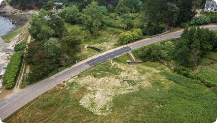
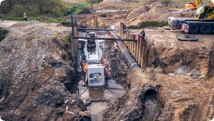
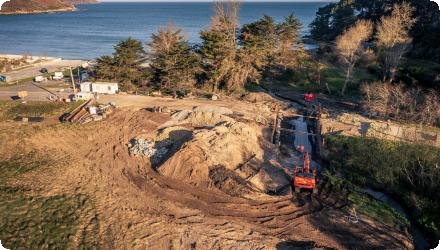
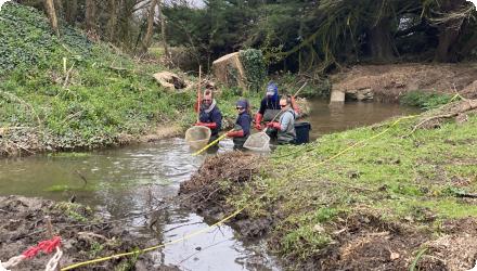
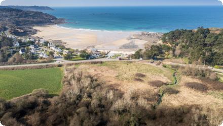
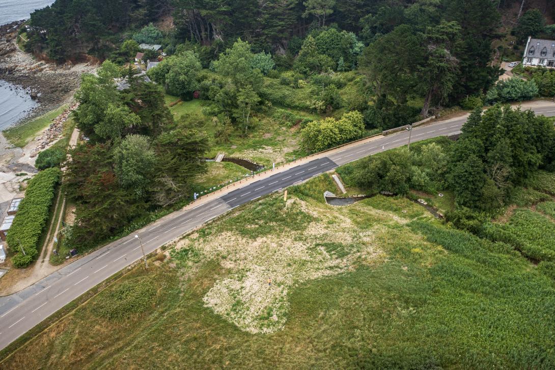
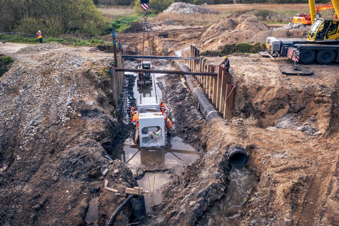
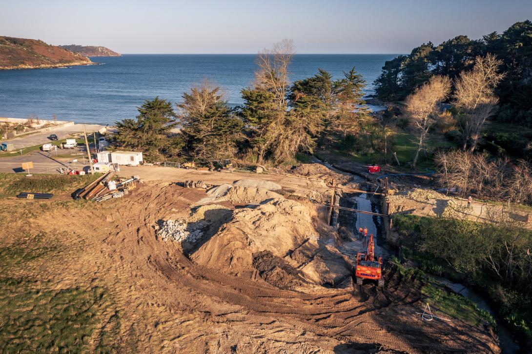
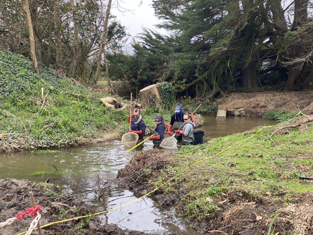
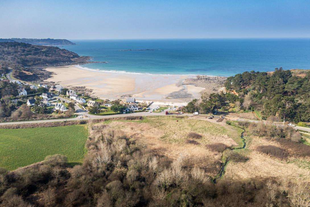
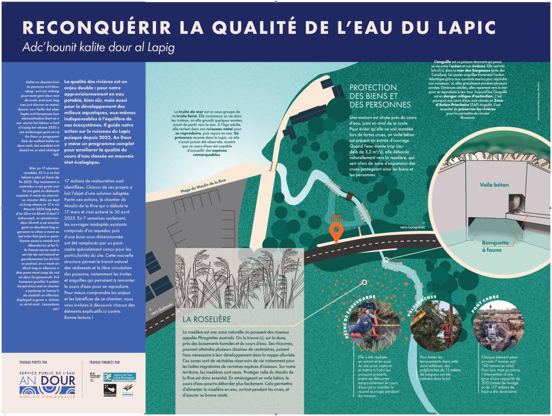
At Locquirec’s Moulin de la Rive, the old aqueduct and undersized culvert on the Lapic blocked fish migration and sediment transport and created a drop that proved impassable, despite the site being a priority action zone for eel and sea trout. Rescue electrofishing during works confirmed the barrier effect, with far fewer eels and trout upstream than downstream. The project replaced the structure with a 20 m precast frame bridge set 60 cm lower than the former invert, restored a more natural bed with stone and blocks, and added a concrete control wall at the inlet so that high flows can safely spill into the upstream wetland reedbed. The design also integrates a faunal shelf for mammals and bat roosting blocks under the deck, and it secured vulnerable sewer lines that lay near the channel bed. Implementation required careful coordination around numerous underground utilities and a tight spring window to avoid the summer tourism season, combined with strong, proactive communication with residents, surfers and local associations. Traffic on RD64 was diverted from 17 March, and the route reopened ahead of schedule on 30 April 2025. Funding came from Agence de l’Eau Loire-Bretagne, Région Bretagne and Morlaix Communauté. Early observations show fish passage working, otter prints upstream and downstream, macrophyte recovery and rapid revegetation of disturbed zones. The project contributes to WFD ecological continuity targets in a basin facing multiple pressures, including agricultural pollution, hydrocarbons from runoff and intensive anthropogenic footprint.
Position
Latitude
48.687
Longitude
-3.674
Installation date
2025
Implementation Status
Contact
Service Public de l’Eau An Dour
Transboundary
0
Photo gallery
Location of the project
Moulin de la Rive, Locquirec, Finistère, on the river Lapic
NUTS Code
FR52 - Bretagne
Project's objectives
Restore ecological continuity for eel and sea trout
Re-establish sediment transport
Reduce submersion risk at 30 and 100-year horizons while enabling flood expansion into the upstream reedbed
Protect vulnerable sanitation networks at the crossing
Re-establish sediment transport
Reduce submersion risk at 30 and 100-year horizons while enabling flood expansion into the upstream reedbed
Protect vulnerable sanitation networks at the crossing
Involved Partners
| Authority type | Authority name | Role | Comments |
|---|---|---|---|
Climate zone
cool temperate moist
Temperature
11.75°C
Precipitation
995
Annual rainfall range
900 - 1200 mm
Elevation range
0 - 10 m
Vegetation class
Reedbed and wetland upstream, macrophytes recolonising channel margins.
Water bodies: Ecological Status
Poor
Water bodies: Chemical Status
Unknown
Water quality status
Barrier to ecological continuity, agricultural pollution and siltation from vegetable production, hydrocarbon inputs from runoff on impervious surfaces, strong anthropogenic footprint at the crossing
Project scale
Micro
Project scale specification
Single site intervention at one crossing on the Lapic
Performance timescale
Immediate
Project area
20 m long frame bridge.
Lifespan
Design life 80-100 years; 10 years guaranteed by the designers.
Consensus-seeking design acceptable to local users
Lower-impact construction approach with sheet piles and limited earthworks to reduce nuisance
Frame set 60 cm lower than previous invert to restore grade
Inlet control wall to allow floodwater to spread onto the upstream reedbed
Faunal shelf under deck and bat roosting blocks
Channel bed recharge with stones and blocks for habitat diversity
Design capacity description
Frame internal section about 1.5 m by 1.5 m
Inlet control configured so that up to about 3.2 m³/s passes before upstream storage engages
Bed level lowered 60 cm from previous structure
Inlet control configured so that up to about 3.2 m³/s passes before upstream storage engages
Bed level lowered 60 cm from previous structure
High density of underground utilities and need to maintain service
Sandy soils
Busy departmental road requiring detours and bus rescheduling
Sandy soils
Busy departmental road requiring detours and bus rescheduling
Total cost
430,857 €
Costs total information
Project management mission (ING Concept/Verdi Environnement) = €26,529:
Geotechnical Study (Kornog Géotechnique) = €7,782;
Preparatory Work (Kerne Pruning: Felling/Girobroyage) = €17,562
Works (COLAS SA) = €366,087;
Communication (Sky Arts/Norwest Design/Le Friant advertising) = €12,897
Geotechnical Study (Kornog Géotechnique) = €7,782;
Preparatory Work (Kerne Pruning: Felling/Girobroyage) = €17,562
Works (COLAS SA) = €366,087;
Communication (Sky Arts/Norwest Design/Le Friant advertising) = €12,897
Financing authorities
Type of funding
Sub-national funds
Type of funding
Sub-national funds
Type of funding
Local funds
Comments
Co-financing and client via An Dour
Compensations
0
Policy context
Part of a territory contract with the Water Agency aiming at achieving good status on three degraded water bodies by 2030.
Land ownership
Road: Département. Adjacent parcels: multiple private owners. Delegated project management arrangement with the Département to An Dour.
Community involvment
Yes
Design consultation activity
| Activity stage | Name | Key issues | Comments |
|---|---|---|---|
|
Implementation phase
|
Intensive communication
|
Broadly supportive public after intensive communication
|
Professional videos and social media series, photo exhibition, educational panels
|
|
Screening phase
|
Information meetings with local groups, municipal presentation, public meeting
|
With about 80 participants
|
Target Remarks
Restore ecological continuity and improve water quality at the crossing
Maintain service for transport and sanitation networks during works
Maintain service for transport and sanitation networks during works
Pressures remarks
Ecological barrier, agricultural pollution, hydrocarbons, intensive local footprint.
Contractual arrangements
1
| Arrangement type | Responsibility | Role | Name | Comments |
|---|---|---|---|---|
|
Institutional arrangement
|
Department is the road owner. It delegated to An Dour the project owning for this site and for a limited time.
|
Delegation of project management with the Département.
|
Part of wider plan
1
Wider plan type
| Wider plan type | Wider plan focus | Name | Comments |
|---|---|---|---|
|
Catchment-based
|
Water
|
Territory contract with Agence de l’Eau Loire-Bretagne
|
Baseline biological indices IPR and I2M2 at state 0
Follow-ups planned at 2 and 5 years
Visual inspections of hydraulics and wetland expansion
Follow-ups planned at 2 and 5 years
Visual inspections of hydraulics and wetland expansion
Maintenance
An Dour oversees for one year post-works, then the Département for road-related maintenance including debris and vegetation removal.
Qualitative observations to date; quantitative follow-ups planned through standard biological indices.
Positive site feedback on the amenity after works; RD64 reopened earlier than planned.
Information on retained water
The undersized aqueduct–culvert and downstream drop have been removed. The new 20 m frame is set 60 cm lower to remove the hydraulic step and restore a continuous bed profile. An upstream regulating wall lets the Lapic pass up to about 3.2 m³/s through the frame; beyond that threshold the upstream reedbed intentionally takes flow, activating storage and reducing downstream peaks. Visual checks confirm upstream floodplain activation during high water. The upstream end block also narrows the section under flood to protect nearby houses, as designed. Overall effect: reconnect baseflows, re-engage flood storage on the wetland, and make high flows safer for people and infrastructure.
Information on Water quality overall improvements
The works secured vulnerable sewer lines that lay at bed level to prevent rupture risks after the bed lowering, with protective encasement and replacement of sections to limit parasitic inflows. Local authorities report that after the project, Lapic water quality is expected to improve from “poor” to “moderate,” with a basin-wide sanitary action order in preparation to jointly address bacterial sources (collective, individual, and agricultural). These steps complement the crossing redesign by reducing accidental pollution risk and improving flushing of fine sediments.
Fish rescue during works found 160 eels and 81 trout downstream versus 60 eels and 30 trout upstream, confirming the former barrier effect. Barrier removal and a lowered invert now restore longitudinal connectivity for eel and sea trout. Bed recharge with stones/blocks increases habitat heterogeneity. A concrete faunal shelf below the deck provides safe passage for semi-aquatic mammals; blocks fixed to the soffit offer bat roosting features. Early post-works signs include visual fish passage, otter footprints upstream and downstream, macrophyte recolonisation below the structure, and rapid re-greening of worked areas by reeds and sedges.
Key lessons
Know your upstream wetlands and hydraulic control points to right-size the crossing and safely reactivate flood storage. Engage early and communicate a lot to keep acceptance high when closing a key road. Plan around utilities and protect sanitation lines when lowering the channel. Prefer a sober, low-nuisance construction approach to cut truck movements, noise and pollution. Build fauna and roosting features into the crossing rather than treating them as add-ons. Align the site project with basin-scale programmes and transport services so detours and public service continuity are managed from day one.
Success factor(s)
| Success factor type | Success factor role | Comments | Order |
|---|---|---|---|
|
Existing staff and consultant knowledge
|
main factor
|
Competent MOE and contractors |
|
|
Public participation
|
main factor
|
Early and sustained multi-stakeholder engagement, including owners and local groups |
|
|
Communication activities
|
main factor
|
Intensive, anticipatory communication |
|
|
Successful coordination between authorities
|
main factor
|
Good coordination across technical, financial and local actors |
Driver
| Driver type | Driver role | Comments | Order |
|---|---|---|---|
|
Balancing different objectives
|
main driver
|
Significant ecological and risk-management stakes
|
|
|
Organisation committed to it
|
main driver
|
Availability of subsidies and a territory contract framework
|
Transferability
Highly transferable as part of basin-wide continuity programmes, provided it is embedded in broader sponge strategy with agricultural partnerships and GI measures.
Cost effectiveness
Qualitatively strong delivery with early reopening and reported lower works outturn than prevision in press coverage.
Source(s)
English