
ES11 - Aesthetic/cultural value

Code
SU09
Sector
Urban
Year of Issue
2025
Summary

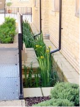
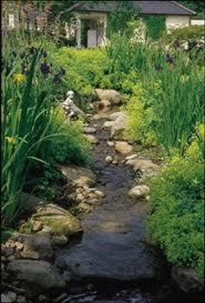
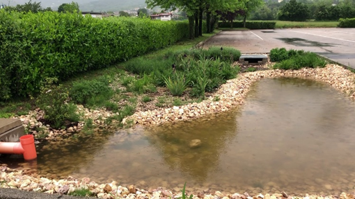
Rain gardens are defined as small-scale vegetated gardens used for storage and infiltration. The term ‘rain garden’ is often used interchangeably with ‘bioretention area’ (although the latter could also be applied more loosely to other measures such as filter strips or swales). 

...

Rain garden (IT)

Source: SpongeScapes project

Possible benefits with level
Benefits Level
ES1 - Water storage
Low
ES3 - Natural biomass production
Low
ES4 - Biodiversity preservation
Medium
ES5 - Climate change adaptation and mitigation
Medium
ES6 - Groundwater/aquifer recharge
Medium
ES7 - Flood risk reduction
High
ES8 - Erosion/sediment control
Low
ES9 - Filtration of pollutants
Medium
ES10 - Recreational opportunities
Medium
ES11 - Aesthetic/cultural value
Medium
PO2 - Improving status of physico-chemical quality elements
Low
PO4 - Improving chemical status and priority substances
Low
PO5 - Improving quantitative status
Medium
PO7 - Prevent surface water status deterioration
Medium
PO8 - Prevent groundwater status deterioration
Low
PO9 - Take adequate and co-ordinated measures to reduce flood risks
High
PO11 - Better protection for ecosystems and more use of Green Infrastructure
High
PO14 - Prevention of biodiversity loss
Medium
BP1 - Store runoff
Medium
BP2 - Slow runoff
Medium
BP5 - Increase evapotranspiration
High
BP6 - Increase infiltration and/or groundwater recharge
High
BP7 - Increase soil water retention
Low
BP8 - Reduce pollutant sources
Low
BP9 - Intercept pollution pathways
Medium
BP10 - Reduce erosion and/or sediment delivery
Medium
BP14 - Create terrestrial habitats
High
BP16 - Reduce peak temperature
Medium
BP17 - Absorb and/or retain CO2
Low
Code
SU05
Sector
Urban
Year of Issue
2025
Other sector(s)
Agriculture
Summary

Channels and rills are shallow open surface water channels incorporated in to the start of a SuDS train. They collect water, slow it down and provide storage for silt deposited from runoff. They can have a variety of cross-sections to suit the urban landscape, and can include the use of planting to provide both enhanced visual appeal and water treatment. 

The main role of channels and rills are to collect runoff at the start of a...

Channel in urban area

Source: susdrain


Rill in urban area

Source: Andras Kis’ presentation, NWRM Workshop 1 


Possible benefits with level
Benefits Level
ES3 - Natural biomass production
Low
ES4 - Biodiversity preservation
Low
ES5 - Climate change adaptation and mitigation
Low
ES7 - Flood risk reduction
Low
ES8 - Erosion/sediment control
Low
ES9 - Filtration of pollutants
Low
ES11 - Aesthetic/cultural value
Medium
PO9 - Take adequate and co-ordinated measures to reduce flood risks
Low
PO11 - Better protection for ecosystems and more use of Green Infrastructure
Low
PO14 - Prevention of biodiversity loss
Low
BP1 - Store runoff
Low
BP2 - Slow runoff
Medium
BP5 - Increase evapotranspiration
Medium
BP6 - Increase infiltration and/or groundwater recharge
Low
BP9 - Intercept pollution pathways
Medium
BP10 - Reduce erosion and/or sediment delivery
Low
BP12 - Create aquatic habitat
Low
BP14 - Create terrestrial habitats
Low
BP16 - Reduce peak temperature
Low
BP17 - Absorb and/or retain CO2
Low
Code
SU06
Sector
Urban
Year of Issue
2025
Other sector(s)
Agriculture
Summary

Filter strips are uniformly graded, gently sloping, vegetated strips of land that provide opportunities for slow conveyance and (commonly) infiltration. They are designed to accept runoff as overland sheet flow from upstream development and often lie between a hard-surfaced area and a receiving stream, surface water collection, treatment or disposal system. 

Filter strips are generally planted with grass or other dense vegetation...

Small filter strip in urban area

Source: Andras Kis’ presentation, NWRM Workshop 1 

Filter strip in agriculture area

Source: 4R Plus

Possible benefits with level
Benefits Level
ES3 - Natural biomass production
Low
ES4 - Biodiversity preservation
Medium
ES5 - Climate change adaptation and mitigation
Low
ES6 - Groundwater/aquifer recharge
Low
ES7 - Flood risk reduction
Low
ES8 - Erosion/sediment control
Medium
ES9 - Filtration of pollutants
High
ES11 - Aesthetic/cultural value
Medium
PO2 - Improving status of physico-chemical quality elements
Low
PO4 - Improving chemical status and priority substances
Low
PO7 - Prevent surface water status deterioration
Medium
PO9 - Take adequate and co-ordinated measures to reduce flood risks
Low
PO11 - Better protection for ecosystems and more use of Green Infrastructure
Medium
PO12 - More sustainable agriculture and forestry
Low
PO14 - Prevention of biodiversity loss
Medium
BP2 - Slow runoff
Low
BP6 - Increase infiltration and/or groundwater recharge
Low
BP7 - Increase soil water retention
Low
BP9 - Intercept pollution pathways
High
BP10 - Reduce erosion and/or sediment delivery
High
BP14 - Create terrestrial habitats
Medium
BP16 - Reduce peak temperature
Low
BP17 - Absorb and/or retain CO2
Low
Code
SN09
Sector
Hydro Morphology
Year of Issue
2025
Summary

Dams and other transversal barriers are obstacles crossing the river section and causing discontinuities for sediment and fauna. Removing them consists in destroying all the obstacles, restoring the slope and the longitudinal profile of the river, therefore allowing re-establishment of fluvial dynamics, as well as sedimentary and ecological...

Hydropower dam removed. Before and after

Source: Dam Removal Europe 


Possible benefits with level
Benefits Level
BP8 - Reduce pollutant sources
Low
BP10 - Reduce erosion and/or sediment delivery
Medium
BP12 - Create aquatic habitat
High
ES2 - Fish stocks and recruiting
High
ES4 - Biodiversity preservation
High
ES7 - Flood risk reduction
Low
ES8 - Erosion/sediment control
Medium
ES12 - Navigation
Medium
ES14 - Energy production
Medium
PO1 - Improving status of biology quality elements
High
PO2 - Improving status of physico-chemical quality elements
Low
PO3 - Improving status of hydromorphology quality elements
High
PO7 - Prevent surface water status deterioration
Low
PO9 - Take adequate and co-ordinated measures to reduce flood risks
Low
PO10 - Protection of important habitats
High
PO11 - Better protection for ecosystems and more use of Green Infrastructure
High
PO13 - Better management of fish stocks
High
PO14 - Prevention of biodiversity loss
High
Code
SU04
Sector
Urban
Year of Issue
2025
Other sector(s)
Agriculture
Summary

Swales are broad, shallow, linear vegetated channels which can store or convey surface water (reducing the rate and volume of runoff) and remove pollutants. They can be used as conveyance features to pass the runoff to the next stage of the SuDS treatment train and can be designed to promote infiltration where soil and groundwater conditions...

Bioswale in Gartz (DE)

Source: UNalab project


Possible benefits with level
Benefits Level
ES1 - Water storage
Low
ES3 - Natural biomass production
Low
ES4 - Biodiversity preservation
Medium
ES5 - Climate change adaptation and mitigation
Medium
ES6 - Groundwater/aquifer recharge
Medium
ES7 - Flood risk reduction
Medium
ES8 - Erosion/sediment control
Low
ES9 - Filtration of pollutants
Medium
ES11 - Aesthetic/cultural value
Medium
PO2 - Improving status of physico-chemical quality elements
Low
PO4 - Improving chemical status and priority substances
Low
PO5 - Improving quantitative status
Low
PO7 - Prevent surface water status deterioration
Medium
PO8 - Prevent groundwater status deterioration
Low
PO9 - Take adequate and co-ordinated measures to reduce flood risks
High
PO11 - Better protection for ecosystems and more use of Green Infrastructure
Medium
PO12 - More sustainable agriculture and forestry
Low
PO14 - Prevention of biodiversity loss
Medium
BP1 - Store runoff
Medium
BP2 - Slow runoff
High
BP5 - Increase evapotranspiration
Medium
BP6 - Increase infiltration and/or groundwater recharge
Medium
BP7 - Increase soil water retention
Low
BP8 - Reduce pollutant sources
Low
BP9 - Intercept pollution pathways
Medium
BP10 - Reduce erosion and/or sediment delivery
Medium
BP13 - Create riparian habitat
Low
BP14 - Create terrestrial habitats
Low
BP16 - Reduce peak temperature
Low
BP17 - Absorb and/or retain CO2
Low
Code
SN10
Sector
Hydro Morphology
Year of Issue
2025
Other sector(s)
Urban
Summary

Riverbanks hold a key position in the functionality of floodplains as they constitute the gradual transition between aquatic and terrestrial ecosystems. However, due to technical constructions, the majority of riverbanks in temperate regions are far from their ecological potential.

...
Stabilisation of natural banks, creation and development of riparian buffers (IT)

Stabilisation of natural banks by vegetation, creation and development of riparian buffers (IT)

Source: OPTAIN project

Bank stabilisation with willow rods woven about willow rods and supporting posts into the bank (UK)

Bank stabilisation with willow rods woven about willow rods and supporting posts into the bank (UK) (Fascine)

Source: Peak Traditional Fencing 

Fascines overgrown with vegetation © Brussels Environment

Fascines overgrown with vegetation © Brussels Environment

Possible benefits with level
Benefits Level
BP1 - Store runoff
Low
BP2 - Slow runoff
Low
BP3 - Store river water
Low
BP4 - Slow river water
Medium
BP5 - Increase evapotranspiration
Medium
BP6 - Increase infiltration and/or groundwater recharge
Low
BP7 - Increase soil water retention
Medium
BP8 - Reduce pollutant sources
Low
BP9 - Intercept pollution pathways
Medium
BP10 - Reduce erosion and/or sediment delivery
High
BP11 - Improve soils
High
BP12 - Create aquatic habitat
High
BP13 - Create riparian habitat
High
BP14 - Create terrestrial habitats
Low
BP16 - Reduce peak temperature
Low
BP17 - Absorb and/or retain CO2
Low
ES1 - Water storage
Low
ES2 - Fish stocks and recruiting
High
ES3 - Natural biomass production
High
ES4 - Biodiversity preservation
High
ES5 - Climate change adaptation and mitigation
Low
ES6 - Groundwater/aquifer recharge
Low
ES7 - Flood risk reduction
Medium
ES8 - Erosion/sediment control
High
ES9 - Filtration of pollutants
High
ES10 - Recreational opportunities
High
ES11 - Aesthetic/cultural value
High
PO1 - Improving status of biology quality elements
High
PO2 - Improving status of physico-chemical quality elements
Medium
PO3 - Improving status of hydromorphology quality elements
High
PO4 - Improving chemical status and priority substances
Medium
PO5 - Improving quantitative status
Low
PO6 - Improving chemical status
Low
PO7 - Prevent surface water status deterioration
High
PO8 - Prevent groundwater status deterioration
Low
PO9 - Take adequate and co-ordinated measures to reduce flood risks
Medium
PO10 - Protection of important habitats
High
PO11 - Better protection for ecosystems and more use of Green Infrastructure
High
PO12 - More sustainable agriculture and forestry
High
PO13 - Better management of fish stocks
High
PO14 - Prevention of biodiversity loss
High
Code
SN07
Sector
Hydro Morphology
Year of Issue
2025
Summary

An oxbow lake is an ancient meander that was cut off from the river, thus creating a small lake with a U form. Reconnecting it with the river consists in removing terrestrial lands between both water bodies, therefore favouring the overall functioning of the river by restoring lateral connectivity, diversifying flows and cleaning the river section of the present oxbow for a better water retention during floods. 

Recent literature...

Possible benefits with level
Benefits Level
BP1 - Store runoff
High
BP2 - Slow runoff
High
BP3 - Store river water
High
BP4 - Slow river water
High
BP5 - Increase evapotranspiration
Low
BP6 - Increase infiltration and/or groundwater recharge
High
BP7 - Increase soil water retention
Medium
BP8 - Reduce pollutant sources
Low
BP9 - Intercept pollution pathways
Medium
BP10 - Reduce erosion and/or sediment delivery
High
BP11 - Improve soils
Low
BP12 - Create aquatic habitat
High
ES1 - Water storage
Medium
ES2 - Fish stocks and recruiting
Medium
ES3 - Natural biomass production
Low
ES4 - Biodiversity preservation
High
ES5 - Climate change adaptation and mitigation
Medium
ES6 - Groundwater/aquifer recharge
Medium
ES7 - Flood risk reduction
Medium
ES8 - Erosion/sediment control
High
ES9 - Filtration of pollutants
Medium
ES10 - Recreational opportunities
Low
ES11 - Aesthetic/cultural value
Medium
PO1 - Improving status of biology quality elements
Low
PO2 - Improving status of physico-chemical quality elements
Low
PO3 - Improving status of hydromorphology quality elements
High
PO4 - Improving chemical status and priority substances
Medium
PO5 - Improving quantitative status
Medium
PO6 - Improving chemical status
Medium
PO7 - Prevent surface water status deterioration
Medium
PO8 - Prevent groundwater status deterioration
Low
PO9 - Take adequate and co-ordinated measures to reduce flood risks
High
PO10 - Protection of important habitats
High
PO11 - Better protection for ecosystems and more use of Green Infrastructure
High
PO12 - More sustainable agriculture and forestry
Low
PO13 - Better management of fish stocks
Medium
PO14 - Prevention of biodiversity loss
High
Code
SN12
Sector
Hydro Morphology
Year of Issue
2025
The complete description of the NWRM
Summary

Ongoing climate change affects lake water quality through several mechanisms, including (1) changes in external and internal nutrient loads, (2) increased frequency of extreme events such as hurricanes, (3) temperature-induced changes in biota and biotic interactions, and (4) fluctuations in water levels.
Lakes function as important water retention systems, capable of storing water for flood control and providing water for multiple uses...

Pochina Lake after restoration (RO)
Source: Restoring Europe’s Rivers
 

Possible benefits with level
Benefits Level
BP1 - Store runoff
High
BP2 - Slow runoff
Medium
BP3 - Store river water
High
BP4 - Slow river water
Medium
BP5 - Increase evapotranspiration
Low
BP6 - Increase infiltration and/or groundwater recharge
Low
BP7 - Increase soil water retention
Low
BP9 - Intercept pollution pathways
Low
BP10 - Reduce erosion and/or sediment delivery
High
BP11 - Improve soils
Low
BP12 - Create aquatic habitat
High
BP13 - Create riparian habitat
High
ES1 - Water storage
High
ES2 - Fish stocks and recruiting
High
ES3 - Natural biomass production
High
ES4 - Biodiversity preservation
High
ES6 - Groundwater/aquifer recharge
Medium
ES7 - Flood risk reduction
Medium
ES8 - Erosion/sediment control
High
ES9 - Filtration of pollutants
Low
ES10 - Recreational opportunities
High
ES11 - Aesthetic/cultural value
High
PO1 - Improving status of biology quality elements
High
PO2 - Improving status of physico-chemical quality elements
Medium
PO3 - Improving status of hydromorphology quality elements
Medium
PO4 - Improving chemical status and priority substances
Low
PO5 - Improving quantitative status
Low
PO6 - Improving chemical status
Low
PO7 - Prevent surface water status deterioration
Medium
PO8 - Prevent groundwater status deterioration
Low
PO9 - Take adequate and co-ordinated measures to reduce flood risks
Medium
PO10 - Protection of important habitats
High
PO11 - Better protection for ecosystems and more use of Green Infrastructure
High
PO13 - Better management of fish stocks
High
PO14 - Prevention of biodiversity loss
High
Code
SF01
Sector
Forest
Year of Issue
2025
Other sector(s)
Agriculture
Urban
Hydro Morphology
Summary

Riparian buffers are areas of land, predominantly covered with trees, shrubs, and sometimes grasses, along, and often up-gradient from, streams, watercourses, or water bodies. These natural or restored buffers serve multiple purposes. By maintaining a relatively undisturbed zone adjacent to open water, they play an important role in water quality and flow...

llustration 21: Riparian Forest buffer

Source: Amy Chadwick, Watershed Consulting

Illustration 22: Riparian buffer of white willow and white poplar (BU)

Source: WWF Bulgaria

Possible benefits with level
Benefits Level
BP1 - Store runoff
Medium
BP2 - Slow runoff
Medium
BP4 - Slow river water
Low
BP5 - Increase evapotranspiration
Low
BP6 - Increase infiltration and/or groundwater recharge
Low
BP7 - Increase soil water retention
Low
BP8 - Reduce pollutant sources
Medium
BP9 - Intercept pollution pathways
Medium
BP10 - Reduce erosion and/or sediment delivery
High
BP11 - Improve soils
Low
BP12 - Create aquatic habitat
Medium
BP13 - Create riparian habitat
High
BP14 - Create terrestrial habitats
Low
BP16 - Reduce peak temperature
Medium
BP17 - Absorb and/or retain CO2
Low
ES1 - Water storage
Low
ES2 - Fish stocks and recruiting
Medium
ES3 - Natural biomass production
Low
ES4 - Biodiversity preservation
High
ES6 - Groundwater/aquifer recharge
Low
ES7 - Flood risk reduction
Low
ES8 - Erosion/sediment control
High
ES9 - Filtration of pollutants
Medium
ES10 - Recreational opportunities
Low
ES11 - Aesthetic/cultural value
Low
ES12 - Navigation
Low
PO1 - Improving status of biology quality elements
Medium
PO2 - Improving status of physico-chemical quality elements
Medium
PO3 - Improving status of hydromorphology quality elements
Medium
PO4 - Improving chemical status and priority substances
Low
PO6 - Improving chemical status
Low
PO7 - Prevent surface water status deterioration
Medium
PO8 - Prevent groundwater status deterioration
Low
PO9 - Take adequate and co-ordinated measures to reduce flood risks
Low
PO10 - Protection of important habitats
Medium
PO11 - Better protection for ecosystems and more use of Green Infrastructure
High
PO12 - More sustainable agriculture and forestry
Medium
PO13 - Better management of fish stocks
Medium
PO14 - Prevention of biodiversity loss
Medium
Code
SN05
Sector
Hydro Morphology
Year of Issue
2025
Summary

Streambed (or riverbed) represents the bottom of the river, including each bank. In the past, riverbeds have been artificially modified with concrete or big boulders, altering flows and reducing habitat for wildlife and vegetation diversity. The changes were aimed at preventing flood or supporting changes of agricultural practices for example. This has led to more...

Possible benefits with level
Benefits Level
BP3 - Store river water
High
BP4 - Slow river water
High
BP5 - Increase evapotranspiration
Low
BP6 - Increase infiltration and/or groundwater recharge
High
BP7 - Increase soil water retention
Low
BP9 - Intercept pollution pathways
Medium
BP10 - Reduce erosion and/or sediment delivery
High
BP11 - Improve soils
Medium
BP12 - Create aquatic habitat
High
BP13 - Create riparian habitat
High
BP14 - Create terrestrial habitats
Low
BP16 - Reduce peak temperature
Medium
BP17 - Absorb and/or retain CO2
Low
ES1 - Water storage
Low
ES2 - Fish stocks and recruiting
Low
ES3 - Natural biomass production
Medium
ES4 - Biodiversity preservation
High
ES6 - Groundwater/aquifer recharge
Low
ES7 - Flood risk reduction
Medium
ES8 - Erosion/sediment control
High
ES9 - Filtration of pollutants
Medium
ES10 - Recreational opportunities
Medium
ES11 - Aesthetic/cultural value
Medium
PO1 - Improving status of biology quality elements
High
PO2 - Improving status of physico-chemical quality elements
Low
PO3 - Improving status of hydromorphology quality elements
Medium
PO4 - Improving chemical status and priority substances
Medium
PO5 - Improving quantitative status
Low
PO7 - Prevent surface water status deterioration
Medium
PO8 - Prevent groundwater status deterioration
Medium
PO9 - Take adequate and co-ordinated measures to reduce flood risks
Medium
PO10 - Protection of important habitats
High
PO11 - Better protection for ecosystems and more use of Green Infrastructure
High
PO13 - Better management of fish stocks
High
PO14 - Prevention of biodiversity loss
High